3:4
and September in each year', offenders to be liable 'to a penalty not exceeding £5 sterling ($10) for each separate offence or breach.
By the turn of the century the province was enjoying a fairly prosperous period. The county council, under the chairmanship of Henry Okey, who held that position from 1896 to 1905, had the roading pattern largely complete, although much of it was unmetalled, passable only to horse-drawn traffic and bullock wagons. With the coming of the motor vehicle the situation improved, and by 1914 most county roads had been metalled and a policy of sealing was being implemented. Roads and streets in townships were up- graded to town standards, and by 1956 a major scheme to seal every road to every ratepayer's gate was inaugurated.
This was completed within the 10-year programme time. Meanwhile the county council found its responsibilities growing. Although roading remained-and probably always will remain its primary function, it now administers the control of noxious weeds, the issue of motor vehicle, dog and food licences and building and associated permits. Since the early 1960s it has had control of county subdivisions, administration of the Town Planning Act and the con- sequent town planning schemes, water and sewerage schemes. There have been 12 chairmen of the county council since its formation. Other than Laurie' Hickford, the longest serving was S. Vickers, who was a councillor continuously for 33 years and chairman from 1934 to 1950 when he retired as chairman but retained his seat on the council. (One of his descendants, Ken Vickers, joined the staff of the county council in the late 1930s. In 1979 he was still employed as an overseer). Longest serving county clerk was R., O. Ellis (1905-1935). The present clerk is J. S. Putt, appointed in 1957. T. K. Skinner was the first permanent engineer to the county council. John Skinner, his brother, was his successor; he built the first concrete bridges in the county.
The present engineer is R. W. Struthers, appointed in 1954. In spite of the fact that at its first meeting in 1876 a deputation waited on Major Atkinson, M.H.R. to urge the necessity of 'preparing suitable buildings for the use of public bodies', up until 1910 the council leased its offices and council room. In that year a site at the corner of Robe and Powderham Streets was bought on which a building was erected which served the council until 1968 when a section next door was acquired and the present office block was built. In 1980 the council employed a staff of 80.
Each time New Plymouth has extended its boundaries to cope with increased population, there has been dispute and controversy, mainly because this has been done at the expense of the county. The first significant move to widen the town region came with the greater New Plymouth scheme in 1911 (completed by 1913) when the Fitzroy district, Vogeltown, Frankleigh Park and the Westown and Moturoa area were embraced.
As a result of this no substantial extension were necessary for nearly 50 years. Minor alterations to boundaries occur- red in 1931 and 1941, when the seafront area omitted from the greater New Plymouth scheme was added and in 1955 a block of land was acquired on Omata Road. Shortly after this negotiations began on a more extensive scheme to add further land to the city. In October 1956 the city council approached the county council to ascertain its attitude to further boundary extensions. Final agreement was reached in June, 1958, and the merger was finalised in 1960.
The increased area took in a large block of land south of Paritutu, including Centennial Park; two additions to the south of the town at Hurdon, Ferndale and Huatoki; and an area straddling Mangorei Road bounded by the Henui Stream and Waiwakaiho River.
From Carrington's designed plan of a town of .320 ha in 1842, the city had by 1980 embraced 2316 ha, excluding a large built-up area at Bell Block which was administered by the county council. Most of the additions swallowed up fertile farm land, and this caused concern to the county council. Despite differences (the two newspapers have often been criticised for over-emphasis and adverse comment on these differences) both councils have maintained good, if on occa- sions somewhat spirited, relations in their planning for the common good.
This was never more clearly demonstrated than in 1977, when the council designated 160 ha in the county between Fitzroy and Bell Block as Hickford Park. It was a fitting memorial to Laurie Hickford, whose 41 years on the council was an example of co-operation between city and county administrators. The land, which had been owned by the Taranaki Harbours Board and which required an Act of Parliament to transfer it, was planned 'as a recreation area-beaches and a bit of wilderness for children-something like Rotten Row in London, where people can get their horses out and have a good gallop, because days are now past when horses can use the roads, or the beaches. The area will include a walkway right down to the banks of the Waiwakaiho River, down to the beach and along to Bell Block to an enlarged sports area. There will be extensive tree plantings.
Shortly before his death in 1977 Hickford commented: 'I know of no other city anywhere in the world where the same facilities exist within a reasonable radius-beaches, trout fishing, mountain and bush walks-we've got the lot. And developing these, as well as carrying on all the other activities of the council, should be our aim in the future.
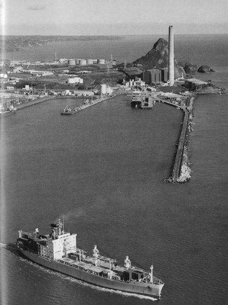
North Taranaki farmers have long regarded New Plymouth as 'their' town: it only existed because of the rural industry which depended on the land's future. This was true for most of the town's first century, and will no doubt continue to be so to a lesser degree. When an industrial explosion began in the late 1960s it was soon realised there was not enough land within the city boundaries to contain it. A 204 ha block at Bell Block was zoned as an industrial and manufacturing area, with regional and national distribution of products. By 1980 a further 63 ha had been set aside for industry under control of the city and county councils.